The images below show seasonal outlooks for November 2020 to January 2021, for temperature and precipitation, and for Fall Freeze-up and March maximum sea ice extent. More details can be found in the Seasonal outlook for November-December-January 2020-21 presentation and the Sea‐Ice Outlook for Winter 2020/21 presentation.
Temperature NDJ 2020-21 Outlook
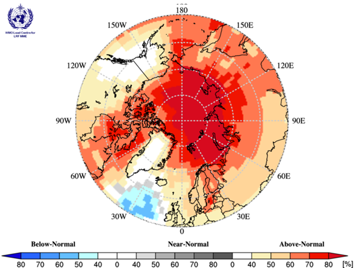
The figure below shows multi-model ensemble probability forecast for surface temperature for November 2020, December 2020, and January 2021 (NDJ). Source: www.wmolc.org.
Surface air temperatures during winter 2020-2021 are forecast to be above normal across the majority of the Arctic regions (yellow, orange and red areas). The confidence of the forecast is low to moderate over Alaska, Canada, Eastern Siberia, and the Chukchi and Bering regions (yellow and orange areas), and high over the Eastern Nordic, Western Siberia, and Central Arctic regions (dark red areas). The multi-model ensemble did not agree over central Alaska and most of Greenland (white areas).
Precipitation NDJ 2020-21 Outlook
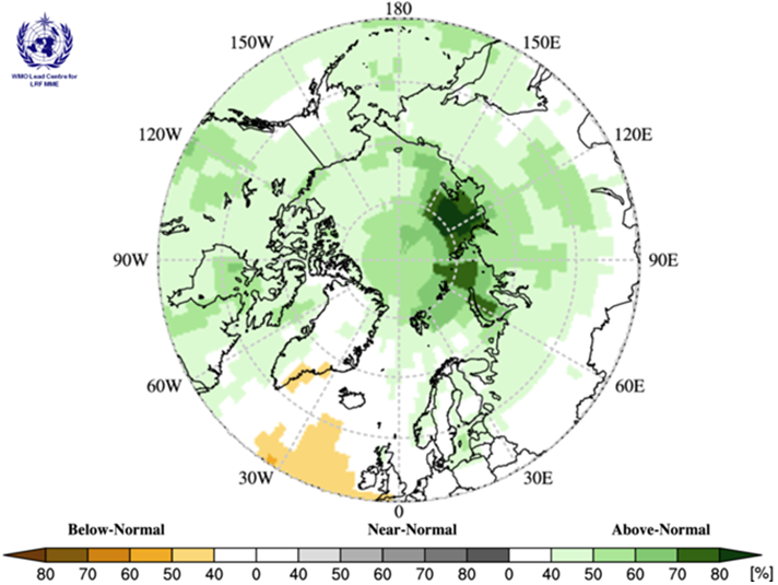
The figure below shows multi-model ensemble probability forecast for precipitation for the NDJ 2020-21 period. Source: www.wmolc.org.
Precipitation during winter 2020-2021 is forecast to be above normal over the majority of the Arctic region. Forecast confidence is primarily low (light green areas), with the exception of the northern parts of the Western and Eastern Siberia regions, and parts of the Central Arctic region, where forecast confidence is moderate (dark green areas). The multi-model ensemble did not agree over the majority of the Western Nordic region (white areas).
Outlook for fall Freeze-up 2020 and March 2021 Maximum Sea Ice Extent
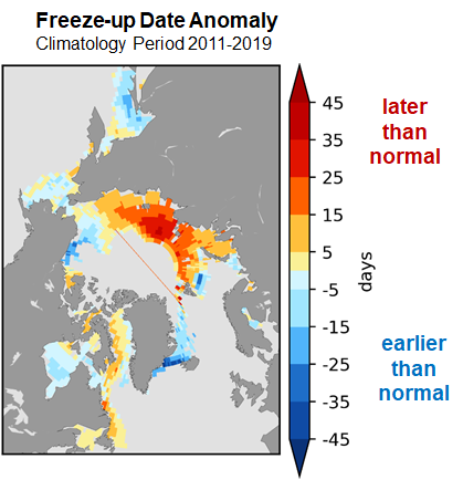
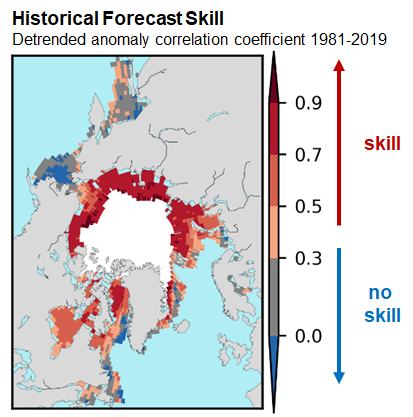
Sea-ice freeze-up is defined as the date where ice concentration exceeds 50% in a region. The outlook for fall freeze-up shown in the figure below displays the sea-ice freeze-up anomaly from CanSIPSv2 based on the nine-year climatological period from 2011-2019. The qualitative 3-category (high, moderate, low) confidence in the forecast is based on the historical model skill. Only regions where the model has historical skill are included in the outlook.
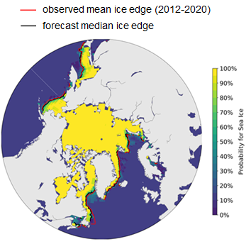
Maximum sea-ice extent is normally achieved each year during the month of March in the northern hemisphere. The figure below displays the probabilities of sea-ice presence for concentrations greater than 15% and the forecasted mean ice extent from CanSIPSv2 (black), with the observed median sea-ice extent for the 2012-2020 period in red. The sea-ice extent is expected to be below normal for the Northern Baltic Sea, the Gulf of St. Lawrence, and the Labrador Sea, and near normal for the Barents Sea, the Bering Sea, the Greenland Sea, and the Sea of Okhotsk.