
The images below show the seasonal outlook for November, Desember and January 2018-2019 for temperature and precipitation, fall freeze-up time, and March 2019 sea ice extent. More details can be found in the temperature and precipitation seasonal forecast presentation and in the sea ice forecast presentation. Overall the Winter 2018-19 outlook shows a significantly warmer climate than normal with implications for precipitation and sea ice. We expect above normal temperatures over the Arctic, and above normal precipitation over the Arctic, with an exception of Scandinavia, eastern Russia, Alaska and eastern Canadian Archipelago. The forecast predicts earlier than normal Fall freeze-up in Hudson Bay, Baffin Bay and the Beaufort Sea, and later than normal freeze-up across most of the eastern Arctic from the Barents to Chukchi Seas. For the 2019 March ice extent, we expect below normal ice extent in the Bering Sea and below to near normal ice extent in the Barents Sea and Sea of Okhotsk.
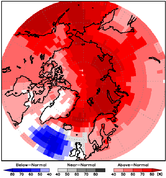
The multi-model ensemble (MME) probability forecast for surface temperature for November, December and January (NDJ) 2018-2019 period show there is probability of 50% or more that temperatures will be above normal in the Alaskan region (red areas in the figure above). Over most of the continental Canadian Arctic, this probability is somewhat smaller, around 40% for above normal temperature. White areas represent regions where the forecast was inconclusive, shown over Greenland with an exception of the northern region where there is at least 40% chance for above normal temperatures. Over the Scandinavian region and over Iceland there is at least a 40% chance for above normal temperatures. Somewhat higher probabilities (around 60%) are expected over northern Norway and Finland. Over the entire Russian Arctic, above normal temperatures are expected for NDJ 2018-2019. Highest probabilities for this outcome are of at least 70% chance over the central and western Russian Arctic. Over the eastern Russia, there is at least a 50% chance for above normal temperatures.
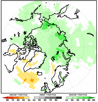
The figure shows the MME probability forecast for precipitation for NDJ 2018/2019. The green areas show the probability of above normal precipitation. There is a probability of 40% or more for above normal precipitation over the entire Canadian and Russian Arctic with some exceptions over the eastern Russia, Baffin Island and Hudson Bay, where the model was inconclusive. Over Scandinavia, Iceland, Greenland and over most of the Alaskan region the model was again inconclusive. In the northern Atlantic region, there is at least 40% chance for below normal precipitation (orange areas), likely linked to high probabilities for below normal temperatures over this region.
For the sea ice outlook, the timing of freeze-up is described for specified regions as earlier than normal, near normal and later than normal. The March sea ice extent is described as below normal, near normal and above normal. These categories are defined in relation to average conditions during the preceding nine years 2009-2017.
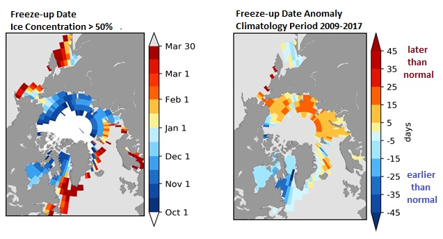
The figure shows the forecast for the 2018 Fall freeze-up (a) actual freeze-up date and (b) anomaly (difference from normal) based on the 2009-2017 period. The freeze-up date is first day when the ice concentration exceeds 50%.
|
Region |
Fall freeze-up |
Confidence |
|---|---|---|
|
Hudson Bay/Baffin Bay/Labrador Sea |
earlier than normal |
[moderate to high confidence] |
|
Gulf of St. Lawrence |
near normal |
[low confidence] |
|
Greenland Sea |
near normal |
[moderate confidence] |
|
Barents Sea |
later than normal |
[moderate confidence] |
|
Kara/Laptev/East Siberian Seas |
later than normal |
[moderate to high confidence] |
|
Chukchi Sea |
later than normal |
[high confidence] |
|
Beaufort Sea |
earlier than normal |
[high confidence] |
|
Sea of Okhotsk |
near normal |
[low confidence] |
|
Bering Sea |
later than normal |
[low confidence] |
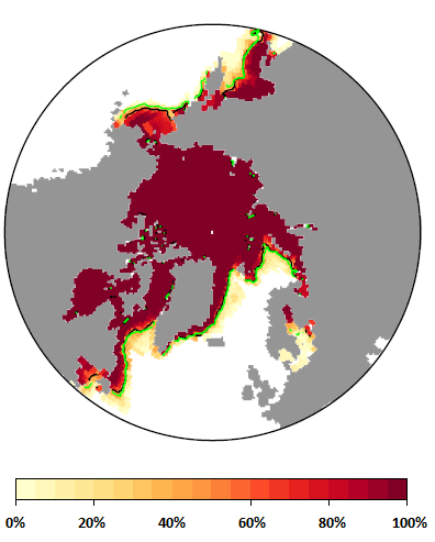
The figure shows the March 2019 probability of sea ice at concentrations greater than 15% from CanSIPS (ECCC). Ensemble mean ice extent from CanSIPS (black), observed mean ice extent 1998-2017 (green), 2009-2017 average March ice extent (yellow).
|
Region |
Sea-ice extent |
Confidence |
|---|---|---|
|
Greenland Sea |
near normall |
[low confidence] |
|
Gulf of St. Lawrence |
below normal |
[low confidence] |
|
Bering Sea |
below normal |
[moderate confidence] |
|
Barents Sea |
below to near normal |
[moderate confidence] |
|
Sea of Okhotsk |
below to near normal |
[moderate confidence] |
|
Labrador Sea |
below to near normal |
[low confidence] |